Showing posts with label Africa. Show all posts

Thursday, 29 December 2011

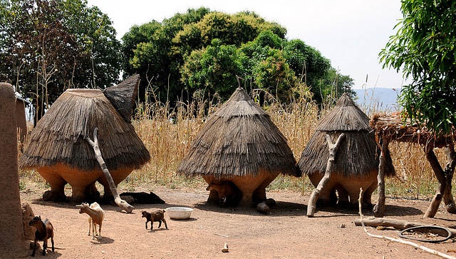
Rural structures in Koussoukoingou, Benin

On Thursday, 29 December 2011 Your comment is first

image
Rural structures in Koussoukoingou, Benin

Benin is a small country in West Africa. It covers 112,622 sq km and has a population of about 9 million people (2011 estimate). Benin is bordered by Togo to the west, Niger and Burkina Faso to the north, and Nigeria to the east. The capital is Porto-Novo while the biggest city is Cotonou. Benin is a multiparty democracy with the president as head of state. The official language here is French, although indigenous languages such as Fon and Yoruba are also commonly spoken. The Roman Catholic faith is the predominant religion in Benin, followed by Islam, Vodun and Protestant. Benin is one hour ahead of Coordinated Universal Time. Traffic is on the right side of the road. Phone IDD code here is +229. The West African CFA franc (XOF) is the official currency. In 2009, Benin has a nominal GDP of $6.6 billion, equivalent to a per capita nominal GDP of $709. The per capita GDP at purchasing power parity is $1,440.

Benin was originally the Kingdom of Dahomey, a name in used in the colonial period until the country gained independence on 30 November, 1975. The new name was chosen to achive neutrality for the different ethnic groups, as the former Kingdom of Dahomey only covered the southern third of the present country.

Ruins of the Kingdom of Dahomey are today the major tourist attractions in Benin. The country is also the birthplace of Voodoo, known here as Vodun. It remains the official religion of the country.


Wednesday, 28 December 2011

Swaziland

On Wednesday, 28 December 2011 Your comment is first

image
Swaziland Beehive Hut
Swaziland is a small, landlocked country in southern Africa. The country, which is an absolute monarchy headed by King Mswati III, covers 17,364 sq km (6,704 sq mi) and has a population of 1.2 million people (2011 estimate). Swaziland is bordered by South Africa to the west and Mozambique to the east. The royal capital of Swaziland is Lobamba while the administrative capital is at Mbabane. English and SiSwati are the two official languages of Swaziland. Swaziland is two hours ahead of Coordinated Universal Time (UTC+2). The official currency of the country is called the Lilangeni. Traffic is driven on the left, just as in Britain. The phone IDD code is +268.

Swaziland has a diversified economy. In 2009, the country has an estimated nominal GDP of $2.983 billion, equivalent to a per capita nominal GDP of $2,907. The per capita GDP at purchasing power parity is $5,708. Swaziland is located on a geological fault line that cuts through the eastern part of Arica, from the Drakensberg Mountains in Lesotho, through Zimbabwe, the Great Rift Valley in Kenya and ended in Turkey. It experiences a climate that can be described as between tropical and temperate. Average temperature varies from 20°C (68°F) in summer (November through March) to 13°C (55.4°F) in winter (June through August).

Evidence of human habitation in Swaziland goes back 200,000 years, to the early Stone Age. Since the 19th century, Swaziland has enjoyed a degree of autonomy from British rule, even though, due to mining rights, the country was placed under the South African Republic. During the Second Boer War (1899-1902), the colonials evacuated and left Swaziland under the care of its monarch, Ngwane V. Swaziland was under the British for the first half of the 20th century, until it attained its independence on 6 September, 1964.


Taberma Valley, Togo

On Your comment is first

image
Taberma Valley House
The name of the tribe who live here is Taberma which means ‘good builder’. They are known for their unique architecture. Each compound consists of tall towers connected by high walls, made from a material called banco, a mixture of clay and straw. No tools are used in the construction of these buildings, which are now on the UNESCO heritage list. Everything these people do, in all aspects of their lives, is based on readiness to fight, including entering the Takienta (compound) backwards. That way they can be ready facing the outside world if the enemy should attack; never be taken by surprise.

There are 37 different ethnic groups in Togo, of which the Taberma are one minority who live in the north of Togo and neighbouring Benin. There is only one entrance in the walls of the Takienta, and that will always face west out of nostalgia the Taberma people hail from South Burkina Faso. The door is fashioned like a face/head, with the eyes being the holes near the top (the entrances for the spirits), the stripes in the middle the nose and the doorway the mouth. The first room you come to when you enter is where the animals are kept under the main terrace, away from rain and the enemy.


Pyramids of Giza

On Your comment is first

image
Pyramids of Giza
The pyramids of Giza are perhaps the only true rival to the Great Sphinx when one thinks of ancient Egypt and its architecture. The Valley of Giza -- with its wonderful monuments -- is truly a marvel of architectural prowess. The three largest pyramids located in the valley consist of the Great Pyramid of Khufu, the Pyramid of Kafhre and the Pyramid of Menkaura.

The Great Pyramid of Giza enjoys special status among the "Seven Wonders of the Ancient World". None of the others have survived into the modern era. The construction, date, and possible symbolism of the Giza pyramids are still not entirely understood. This mystery only adds to the attractiveness of these ancient wonders and many modern people still regard Giza as a spiritual place. A number of fascinating theories have been offered to explain the "mystery of the pyramids".

Everytime I visit such a famous place like pyramids of Giza, I'm faced with a challenge that this place was photographed probably a trillion times and it is nearly impossible to come with something original. The day I visitted Giza valley rewarded me with some wonderful sky with clouds that created nice shadows passing over pyramids. This "caravan" of camels appeared just at the right place and time to give the photo timeless feel.


Tuesday, 27 December 2011

Rock-Hewn Churches

On Tuesday, 27 December 2011 Your comment is first

image
Rock - Hewn Church   Lalibela, Ethiopia
The 11 medieval monolithic cave churches of this 13th-century 'New Jerusalem' are situated in a mountainous region in the heart of Ethiopia near a traditional village with circular-shaped dwellings. Lalibela is a high place of Ethiopian Christianity, still today a place of pilmigrage and devotion.

The rock-hewn churches of Lalibela are exceptionally fine examples of a long-established Ethiopian building tradition. Monolithic churches are to be found all over the north and the centre of the country. Some of the oldest of such churches are to be found in Tigray, where some are believed to date from around the 6th or 7th centuries. King Lalibela is believed to have commissioned these structures with the purpose of creating a holy and symbolic place which considerably influenced Ethiopian religious beliefs.

The 11 medieval monolithic cave churches of this 13th-century 'New Jerusalem' are situated in a mountainous region in the heart of Ethiopia near a traditional village with circular-shaped dwellings. Lalibela is a high place of Ethiopian Christianity, still today a place of pilgrimage and devotion.

Lalibela is a small town at an altitude of almost 2,800 m in the Ethiopian highlands. It is surrounded by a rocky, dry area. Here in the 13th century devout Christians began hewing out the red volcanic rock to create 13 churches. Four of them were finished as completely free-standing structures, attached to their mother rock only at their bases. The remaining nine range from semi-detached to ones whose facades are the only features that have been 'liberated' from the rock.

The Jerusalem theme is important. The rock churches, although connected to one another by maze-like tunnels, are physically separated by a small river which the Ethiopians named the Jordan. Churches on one side of the Jordan represent the earthly Jerusalem; whereas those on the other side represent the heavenly Jerusalem, the city of jewels and golden sidewalks alluded to in the Bible.

It was King Lalibela who commissioned the structures, but scholars disagree as to his motivation. According to a legendary account, King Lalibela was born in Roha. His name means 'the bee recognizes its sovereignty'. God ordered him to build 10 monolithic churches, and gave him detailed instructions as to their construction and even their colours. When his brother Harbay abdicated, the time had come for Lalibela to fulfil this command. Construction work began and is said to have been carried out with remarkable speed, which is scarcely surprising, for, according to legend, angels joined the labourers by day and at night did double the amount of work which the men had done during the hours of daylight.

Like more episodes in the long history of this country, there are many legends about this king. One is that Lalibela was poisoned by his brother and fell into a three-day coma in which he was taken to Heaven and given a vision of rock-hewn cities. Another legend says that he went into exile to Jerusalem and vowed that when he returned he would create a New Jerusalem. Others attribute the building of the churches to Templars from Europe.

The names of the churches evoke hints of Hebrew, a language related to the Hamo-Semitic dialect still used in Ethiopian church liturgies: Beta Medhane Alem (House of the Saviour of the World), Beta Qedus Mikael (House of St Michael) and Beta Amanuel (House of Emmanuel) are all reminiscent of the Hebrew beth (house). In one of the churches there is a pillar covered with cotton. A monk had a dream in which he saw Christ kissing it; according to the monks, the past, the present and the future are carved into it. The churches are connected to each other by small passages and tunnels.

image
Rock-Hewn Churches, Lalibela, Ethiopia